
The Dutch Permanent GPS Array (DPGA) consists of about 18 continuously operating GPS (and GLONASS) receivers in the Netherlands and a data and computing centre. The main purpose of the network is to to provide GNSS data to the International GNSS Service (IGS), EUREF Permanent GNSS Network (EPN), EUMETNET GPS water vapour programme (E-GVAP), and other national and international projects, and to facilitate research and educational applications.
Tuesday 18 February, 2025, IGRS (Integrated Geodetic Reference Station) ENSC was installed at the campus of the University of Twente in Enschede. The antenna is a Septentrio chokering antenna, the receiver is a PolaRx5, operated by TU Delft, providing high-rate data files every 15 minutes (1 sec), and hourly (30 sec) and daily (30 sec) RINEX files. [18 Feb 2025]
The local data center in Delft provides data for the first order GNSS infrastructure in the Netherlands. The station setup and data is conform international standards. The stations fullfill different purposes: some of them are active reference stations (AGRS.NL), of which several are co-located with tide gauges along the North Sea coast, others are Integrated Geodetic Reference Station (IGRS) equiped corner reflectors for InSAR. Several stations are part of international networks, such as the International GNSS Service (IGS), Euref Permanent GNSS Network (EPN), and others; the data for these stations is forwarded to regional and global data centers
|
|
Information on the stations, availability, latency, completeness, data quality and the data itself can be obtained from the following links High-rate, hourly and daily RINEX data from the Dutch Permanent GPS Array are available through through the data download (calendar) button above, directory tree (http://gnss1.tudelft.nl/dpga/rinex) and anonymous ftp (ftp://gnss1.tudelft.nl): Download daily RINEX files (30 sec) [ http | ftp ]The RINEX-3 files use long file names like DLF100NLD_20160610000_01D_30S_MO.crx.gz. For dates before March 1, 2022, data is (also) available in the legacy RINEX-2 format, these files use the old naming style with short names like dlf10610.16d.Z. Furthermore, highrate and hourly RINEX-3 data from before January 1, 2016, have been packed in daily zip files like DLF100NLD_2015256UUUU_01H_10S_MO.crx.zip and DLF100NLD_2015256UUUU_15M_01S_MO.crx.zip that can be found in the regular hourly and highrate RINEX repositories. Many receivers are streaming data using the NTRIP protocol, either in RTCM-3, RAW data format, or both. For the NTRIP source table and mount points see NTRIP source table (http://gnss1.tudelft.nl:2101). Tracking statistics for the legacy RINEX-2 files can be still be found on the teqc legacy RINEX2 statistics page. Receiver specific raw data files are available from within the Internet domain of the Delft University of Technology and for authorized users (who need to login using a username and password), and non-anonymous ftp.
|
Several receivers are currently streaming data using the NTRIP protocol, either in RAW data format, RTCM, or both. For the NTRIP source table see
NTRIP source table (http://gnss1.tudelft.nl:2101)The naming convention for the mountpoints is
<STA4>0: RTCM 3.1The station coordinates in the RTCM messages are in ETRF2000, at epoch 2013-07-02 12:00, see the coordinates and velocities page for more information.
<STA4>00NLD0: RTCM 3.2/3.3 with MSM7 messages
<STA4>00NLD1: RAW data in the receiver proprietary format
For more information on the data streams in general and their usage see the websites of EUREF real-time, NTRIP, Global list of real-time GNSS data streams from NTRIP and NASA Global Differential GPS system (GDGPS).
When it comes to coordinates and velocities of the GNSS reference stations there is not a single solution. Coordinates and velocities in various reference frames can be found coordinates and velocities page, with a short explanation.
The stations are operated by the Delft University of Technology (DEOS) and its partners. The Active GPS Reference System for the Netherlands (AGRS.NL) is a subnet of the DPGA, and NTUS is operated jointly by DEOS and the Singapore Land Authority. More information on the contributing subnetworks and related applications is available on separate pages.
An overview of Permanent GNSS reference stations in the Netherlands is available from here.
For more information or questions contact Hans van der Marel.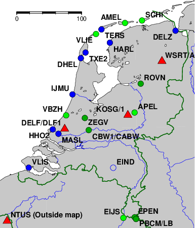 Click on a station to view station info.


