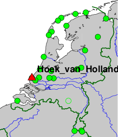
Tide-gauge station Rijks Instituut voor Kust en Zee (RIKZ), Hoek van Holland, The Netherlands.
On-site contact: Kees Hoentjen, Kadaster
GNSS contact: Huib de Ligt, Kadaster
GNSS Instrument(s)
| Name | Marker | Receiver | Antenna | Operator | Network | Start date | End date |
|---|
| hho2 | 13546M001 | LEICA GR50 | LEIAR20 | NSGI | AGRS.NL,TG | 2021-05-18 | |
Markers
| ID | Name | dX | dY | dZ | Instruments | Installed | Removed |
|---|
| 13546M001 | | 0.0000 | 0.0000 | 0.0000 | hho2 | 2021-05-18T00:00Z | |
Pictures
Active instruments
Marker ID: 13546M001
Operator: KADASTER
Log file:
hho200nld_20240319.log
Receiver
| Installed | week/d doy | Removed | week/d doy | Receiver type | S/N | Firmware |
|---|
| 2021-05-18T14:30Z | 2158/2 138 | 2022-03-30T20:50Z | 2203/3 089 | LEICA GR50 | 1870037 | 4.31/7.403 |
| 2022-03-30T20:50Z | 2203/3 089 | 2023-07-03T21:17Z | 2269/1 184 | LEICA GR50 | 1870037 | 4.52/7.711 |
| 2023-07-03T21:17Z | 2269/1 184 | 2024-03-19T21:56Z | 2306/2 079 | LEICA GR50 | 1870037 | 4.61/7.811 |
| 2024-03-19T21:56Z | 2306/2 079 | | | LEICA GR50 | 1870037 | 4.80/7.900 |
Antenna
| Installed | week/d doy | Removed | week/d doy | Antenna type | Dome | S/N | Height | Antenna calibration |
|---|
| 2021-05-18T14:30Z | 2158/2 138 | | | LEIAR20 | LEIM | 17079012 | 0.000 | LEIAR20+S10_____LEIM_17079012.atx |
External Frequency
| Installed | week/d doy | Removed | week/d doy | Ext. Frequency type |
|---|
| 2021-05-18T14:30Z | 2158/2 138 | | | INTERNAL |
Notes
- 2021-05-18T14:30Z 2158/2 138 -
- 2.5 meter stainless steel mast fixed on the side of a 12 meter heigh building approx. 1 m above the roof edge.
For more information contact Hans van der Marel.

